Carrickfergus Old Town Records 1600-1800
A valuable digital resource freely available to researchers.
Carrickfergus Museum holds a number of archival records that can be of use to the family historian.
The town records are an invaluable historical resource for any researcher and having become artefacts in their own right.
They possess a fascinating insight into development of the town.
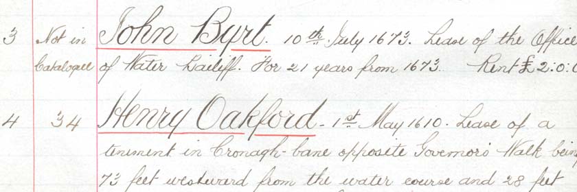
This example was transcribed in 19th century and contains leases for property and land dating from the early 1600s through to the 1800s.
They are a unique resource, allowing us to trace the history of land ownership, building ownership and industry over a period of nearly 400 years.
Family surnames such as Dobbin, Dalway, Faith, Bell and Davys are well represented in these records, and Sir Arthur Chichester is mentioned several times.
In the 19th century, references to industrial companies such as Carrickfergus and Larne Railway and Belfast Water Commissioners, start to appear.
These additions reflect the growth of the town and the need for modern amenities such as transport and an improved water supply.
Developments on the maritime sea-border of Carrickfergus are recorded too, for example, Paul Rodger’s Shipbuilding yard has a record dated 1878.
We are delighted to be able to present this rare archive to the public in a free and accessible format.
The contents are available to view as a flipbook, showing the beautiful script of this record.
Sections relating to the leases have also been transcribed into typed text within a downloadable excel file, which will allow users to search for family names and property addresses in Carrickfergus.
The electronic “flip-book” of the complete archive of the Old Town Records of Carrickfergus, has a basic search facility by pressing both “Ctrl” and “F” keys together.
This will bring up a text box at the upper edge of the window where a string of text such as “Dobbin” can be entered.
On pressing return all instances of this string on pages in the archive are highlighted in yellow, on the schroll bar at base of the window.
The electronic flip-book can be viewed online on our Issuu document platform.
The records can be accessed and used in different formats
- Electronic Flip Book: this contains the complete archive of approximately 90 pages
- Excel spreadsheet this is a full transciption in typeface, which identifies individual digitised records by name, date and page numbers in archive: Carrickfergus Main Capture pp 137-326
- Selected digitised pages in Jpeg format: this allows closer photographic inspection of selected pages from the archive
- Selected digitised pages in Tiff format this also allows closer photographic inspection of selected pages from the archive
Other resources
- 1821 Map: this will viewers at a glance to cross refer to the location of the addresses which appear in the records.
The layout of the streets in the centre of Carrickfergus is little changed from the Medieval period to the present day.
We are grateful to the Public Records Office of Northern Ireland (PRONI) for permssion to use this map on these pages.
The digitisation of the Old Town Records has been made possible thanks to funding from the National Lottery Heritage Fund and Council, through the Carrickfergus Townscape Heritage Initative.
We are grateful to the Centre for Data Digisitation and Analysis, Queen’s University Belfast, for their expertise in digitising and presenting this document, which is held in the care of Carrickfergus Museum.
- Carrickfergus Urban District Council Records of Title of the Corporate Property 1911 - Main Records (xlsx 143 KB)
- Carrickfergus Urban District Council Records of Title of the Corporate Property 1911 - Rentals & Farm Fees (xlsx 54 KB)
- Carrickfergus Urban District Council Records of Title of the Corporate Property 1911 - Leases (xlsx 21 KB)